Join 8,000 Iceland Travel Fans & Unlock Exclusive Discounts
Get Iceland advice straight from a local. Subscribe and unlock exclusive discounts from 50+ hand-picked Icelandic operators.- ✔ Instant access to exclusive discount codes
- ✔ Savings on tours, car, and camper rentals
- ✔ Tips and inspiration for planning your Iceland trip
For geology students, Iceland is not just another beautiful travel destination. It is a giant outdoor classroom where the Earth seems to speak in steam, lava, ice, and stone. Imagine opening a geology textbook and watching the diagrams come alive in front of you. That is what Iceland feels like. One moment you are standing between two tectonic plates, and the next you are walking across a black lava field that looks like another planet.
So, why should geology students add Iceland to their bucket list? Because few places on Earth offer such a rich mix of volcanoes, glaciers, geothermal areas, earthquakes, waterfalls, hot springs, and dramatic landscapes in such a small area. Iceland is raw, young, active, and easy to explore compared with many other geological hotspots. For students who want to understand how Earth works, Iceland is a dream destination.
Iceland Is a Living Geology Textbook
Iceland is often called a living geology laboratory, and for good reason. The island sits in a rare position where major geological forces meet. It is located on the Mid-Atlantic Ridge, where the North American Plate and the Eurasian Plate are moving apart. This alone makes Iceland special because most mid-ocean ridges are hidden deep under the sea. In Iceland, however, students can actually see parts of this plate boundary on land.
Iceland gives geology students an ideal setting for strong dissertation research, from plate tectonics and volcanic activity to glacier movement, geothermal systems, rifting, and landscape formation. Instead of only studying divergent boundaries in class, students can observe real geological processes in the field and turn those observations into original research questions. For example, they might write about lava flow patterns, volcanic hazards, glacial erosion, geothermal energy, or the effects of climate change on Iceland’s landscapes, and when the research process becomes difficult, using professional dissertation writing services at https://edubirdie.com/dissertation-writing-services can help them organize ideas, improve structure, and create a clearer academic paper. This kind of field-based experience not only makes a dissertation more detailed and practical but also helps students build confidence as future geologists.
Iceland is also geologically young. Much of its land has been shaped by relatively recent volcanic activity, glacial movement, and erosion. As a result, many geological features are fresh and easy to recognize. The landscape often feels unfinished, as if the Earth is still sketching its own design.
The Mid-Atlantic Ridge Is Visible on Land
One of the most exciting reasons geology students should visit Iceland is the chance to observe the Mid-Atlantic Ridge above sea level. At places like Þingvellir National Park, students can see dramatic cracks, faults, and rift valleys formed by the movement of tectonic plates. UNESCO recognizes Þingvellir as a World Heritage Site, and it is also one of the most famous geological and historical locations in Iceland.
Standing there, you can think about the slow power of plate movement. The plates do not rush. They move only a small amount each year, but over time, they reshape oceans and continents. It is like watching a very slow dance that has been happening for millions of years.
For geology students, this is powerful. It shows that Earth processes do not always need to be fast to be dramatic. Sometimes, the greatest changes happen slowly, patiently, and constantly.
A Hotspot Adds Extra Fire to the Story
Iceland is not only located on a divergent plate boundary. It is also connected to a mantle plume, often described as a hotspot. This combination helps explain why Iceland has so much volcanic activity. In simple terms, the island gets extra heat from below while the plates above are pulling apart.
This creates a perfect recipe for magma to rise. It also explains why Iceland has frequent volcanic activity, wide lava fields, geothermal areas, and many types of volcanic landforms. According to geological sources such as the Icelandic Meteorological Office and Encyclopaedia Britannica, Iceland is one of the most volcanically active regions on Earth.
For students, this means Iceland is a place where big geological ideas connect. Plate tectonics, mantle processes, volcanic eruptions, earthquakes, and geothermal energy are not separate topics there. They are all parts of the same story.
Volcanoes, Lava Fields, and Geothermal Power Are Everywhere
For many geology students, volcanoes are the main reason to visit Iceland. And honestly, who can blame them? Volcanoes are dramatic, dangerous, creative, and beautiful all at once. They destroy, but they also build. They are like Earth’s fiery artists, painting the land with lava and ash.
Iceland has many volcanic systems, including famous names such as Hekla, Katla, Grímsvötn, Askja, and Eyjafjallajökull. The 2010 eruption of Eyjafjallajökull became globally known because its ash cloud disrupted air travel across Europe. For geology students, that event is a clear example of how local geological activity can have international effects.
Lava fields are another major attraction. In Iceland, students can walk across old flows and observe textures such as rope-like pāhoehoe lava, rough ʻaʻā lava, volcanic cones, craters, and basalt columns. These features help students understand how lava cools, moves, cracks, and changes over time.
Geothermal areas are just as fascinating. Places like Haukadalur, where the famous Strokkur geyser erupts regularly, show how heat beneath the surface interacts with groundwater. Steam vents, mud pots, hot springs, and mineral deposits all tell a story about underground heat and pressure.
Moreover, Iceland uses geothermal energy in everyday life. Many homes are heated with geothermal power, and the country is known for using renewable energy from both geothermal and hydropower sources. For geology students, this connects science with real-world problem solving. It shows how understanding Earth systems can help society build cleaner and smarter energy solutions.
Glaciers and Rivers Shape the Land Like Giant Tools
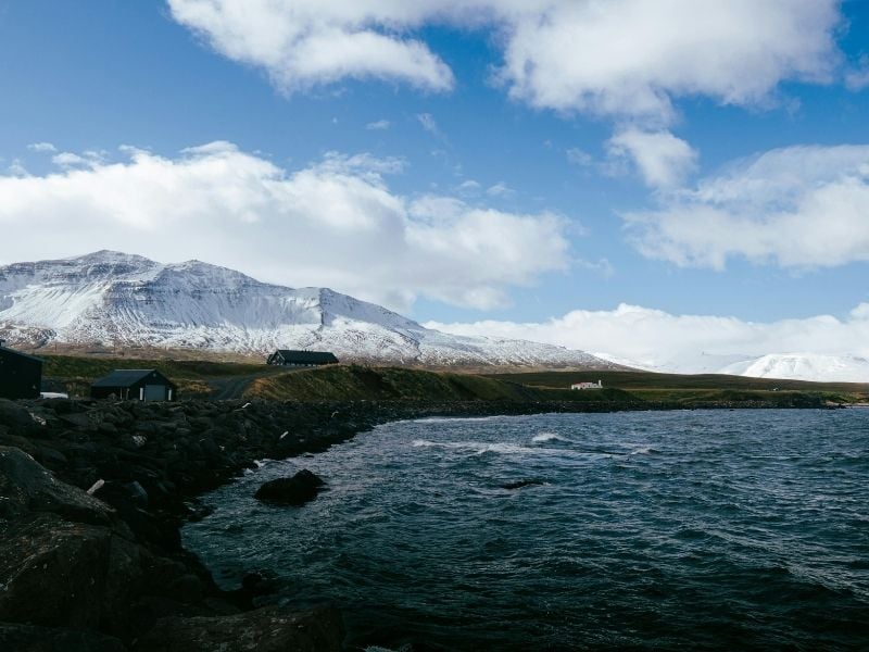
Iceland is not only about fire. It is also about ice. In fact, one of the most exciting things about Iceland is the meeting of volcanoes and glaciers. This contrast gives the country a special kind of beauty. Fire and ice are not just poetic words here; they are real forces shaping the land every day.
Glaciers cover large parts of Iceland, including Vatnajökull, one of Europe’s largest ice caps by volume. Glaciers act like slow-moving machines. They scrape, carve, crush, and carry rock. Over time, they create valleys, fjords, moraines, outwash plains, and other landforms that are important for students studying geomorphology.
For geology students, glacier landscapes are full of clues. Striations on rocks can show the direction of ice movement. Moraines can reveal where a glacier once stopped. Meltwater rivers can show how sediment is sorted and transported. It is like reading footprints left by a giant.
Iceland also offers examples of jökulhlaups, which are sudden glacial floods. These can happen when volcanic heat melts ice under a glacier, causing water to build up and then rush out. Such events can change landscapes very quickly. They also show how connected Earth systems are. A volcanic event under ice can create a flood, reshape rivers, damage roads, and move huge amounts of sediment.
Waterfalls are another highlight. Iceland’s waterfalls are not only beautiful for photos; they are also useful for understanding erosion, rock layers, and river processes. Waterfalls like Gullfoss, Skógafoss, and Dettifoss help students see how water cuts through rock and shapes the land over time.
In this way, Iceland teaches a balanced lesson. Volcanoes may build the island, but glaciers, rivers, wind, and waves keep editing it. The landscape is like a rough draft that nature keeps rewriting.
Field Learning in Iceland Builds Real Geology Skills
Classroom learning is important, but fieldwork is where geology becomes real. In Iceland, students can practice many field skills in one trip. They can observe rock types, sketch landforms, measure structures, identify volcanic deposits, study sediments, and connect local features to larger Earth processes.
This is especially useful because Iceland’s landscapes are often open and visible. In some places, there is little soil or vegetation covering the rocks. That makes it easier to see lava flows, faults, layers, and landforms clearly. For a student still learning how to “read” a landscape, this is a huge advantage.
Iceland also helps students think across scales. A small crack in the ground may connect to a rift system. A lava flow may connect to a volcanic eruption. A river deposit may connect to glacier melt. A hot spring may connect to deep heat beneath the crust. Everything is linked.
Another benefit is that Iceland encourages students to ask better questions. Why is this lava field rough while another one is smooth? Why are these basalt columns shaped like hexagons? Why does steam rise from this valley? Why is the sand black? Why do some areas feel young while others look more weathered?
These questions are the heart of geology. The best geologists are not just people who know facts. They are people who notice patterns, ask smart questions, and connect evidence to explanations.
However, students should also remember that Iceland’s geology is active and sometimes risky. Weather changes quickly, volcanic systems are monitored closely, and some geothermal areas can be dangerous if visitors leave marked paths. Before planning fieldwork, students should check official guidance from sources such as the Icelandic Meteorological Office and SafeTravel Iceland. Good geology is exciting, but safe geology is better.
Iceland also gives students something beyond academic knowledge: inspiration. There is something unforgettable about standing on a black sand beach, watching waves crash against basalt columns, and realizing that the ground under your feet was once molten rock. It makes geology feel alive. It turns theory into memory.
Iceland Belongs on Every Geology Student’s Bucket List
Iceland is one of the best places in the world for geology students because it brings together so many Earth processes in one unforgettable setting. Tectonic plates pull apart, magma rises, volcanoes erupt, glaciers carve valleys, rivers move sediment, and geothermal heat powers daily life. It is a place where the planet feels active, creative, and wonderfully unfinished. For students who want more than classroom notes and exam diagrams, Iceland offers real contact with the forces that shape our world. Adding Iceland to your geology bucket list is not just about travel; it is about seeing Earth’s story written in fire, ice, water, and stone.
Did you enjoy this article?
Get more Iceland insight — straight from a local who's lived here his entire life
Join 8,000 travellers getting honest Iceland advice and unlock exclusive discount codes from 50+ hand-picked Icelandic operators.- ✔ Instant access to exclusive discount codes
- ✔ Savings on tours, car and camper rentals
- ✔ Tips and inspiration for planning your Iceland trip
No spam. Unsubscribe any time.